We're open daily! View holiday hours
Science News
Earth Update - March 2012
March 6, 2012
The Morrison Planetarium’s monthly Earth Update, held as part of “Science Tonight, Live@630” at NightLife, takes visitors on an immersive trip around the world examining current events on our blue planet, including climate, weather, seismic activity, and more. The tour is created by Tim Horn, our producer of climate and earth science visualization.
We like to follow up with an article here, informing our readers about the latest earthly news. We usually start and end in our hometown (or relatively nearby), but this month we’re starting at our home planet, focusing on views of Earth from space.
“How far away in space can you still see Earth?” EarthSky recently asked. Tim answered the question by showing a view of our home planet from the International Space Station, 186 miles away. From the ISS, you can still see major landforms and the lights of cities. But from the Moon, a quarter million miles away, Earth looks like a bright ball in space—not too different from the way the moon looks to us. (EarthSky offers a nice view of this.)
How did John Glenn see Earth from space 50 years ago? NASA’s Earth Observatory offers some highlights:
Along the way, he saw a dust storm and fires in Africa. He observed the glow of moonlight on the cloud tops and the ocean. He saw the wake of a ship and the different colored waters of the Gulf Stream. He saw a “brilliant blue band” on the horizon—the thin, fragile atmosphere of Earth.
Around the same time Glenn first orbited Earth atop an Atlas rocket in a spacecraft dubbed Friendship 7, we began launching satellites to study our home planet and its surroundings, enabling us to expand our scientific understanding of Earth and its cosmic neighborhood. Satellites are our eyes in the sky.
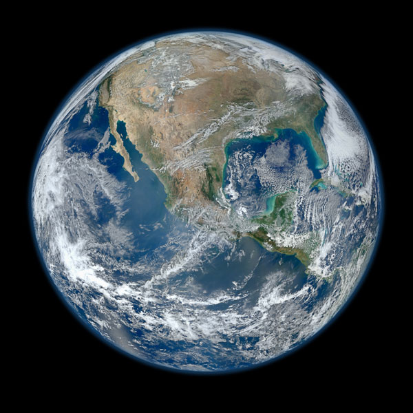
ESA’s Envisat just celebrated its tenth anniversary imaging Earth, and the newbie satellite Suomi NPP (National Polar-orbiting Partnership) and its VIIRS instrument (Visible Infrared Imaging Radiometer Suite) astounded the world with very large “Blue Marble” images recently (pictured above). (Read and see more!)
Space gives us a stunning perspective on Earth’s natural features, whether volcanoes or icebergs. Tim highlighted icebergs off of Antarctica’s Amery Ice Shelf imaged by the Advanced Land Imager (ALI) on NASA’s Earth Observing-1 (EO-1) satellite. This image is a must-see, with ghostly shapes and frazil-rich plumes of color.
From Antarctica, Tim “flew” to the region of Madagascar and the Mozambique Channel where multiple storms struck in early 2012. From Earth Observatory:
Tropical Depression Dando in mid-January, Tropical Cyclone Funso in late January, and Tropical Cyclone Giovanna in mid-February. Then, at the end of February, a fourth storm came to life. Irina started as a tropical storm on February 29. By March 1, the U.S. Navy’s Joint Typhoon Warning Center (JTWC) reported it was a tropical cyclone. Irina had maximum sustained winds of 55 knots (63 miles per hour) with gusts up to 70 knots (80 miles per hour).
Tim ended the journey with satellite images of the Amazon and the deforestation that has taken place over the past ten plus years. Shuffle through these images to see how one area can change dramatically, even from space.
Until next month…
The Suomi NPP Blue Marble, Credit:NASA/NOAA