We're open daily! View holiday hours
Science News
Nabro Volcano
June 29, 2011
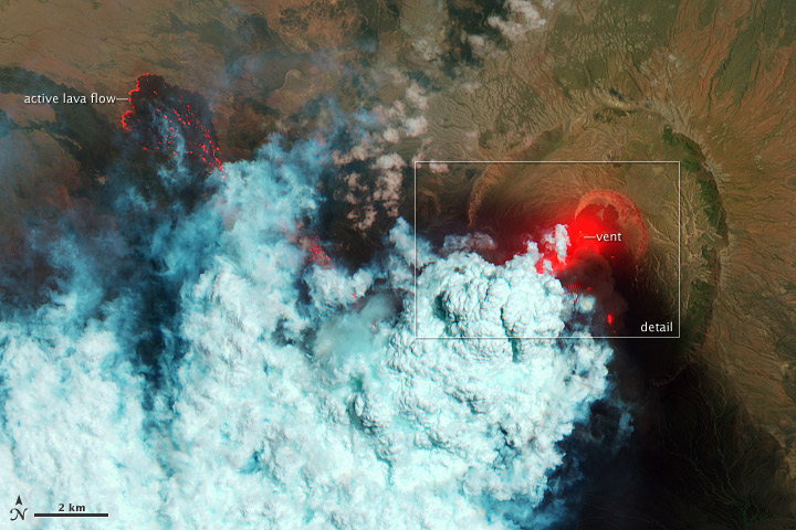
Volcanoes. Lovely to look at, but too hot to hold. NASA’s Earth Observatory recently posted this incredible image of the Nabro volcano in Eritrea, using false color to indicate the heat it’s generating.
As Phil Plait describes in his Bad Astronomy blog on Discover, this image is “pure, freaking, awesome.”
The picture was taken on June 24th, and Robert Simmon of Earth Observatory explains it this way on the website:
The bright red portions of the false-color image indicate hot surfaces. Hot volcanic ash glows above the vent, located in the center of Nabro’s caldera. To the west of the vent, portions of an active lava flow (particularly the front of the flow) are also hot. The speckled pattern on upstream portions of the flow are likely due to the cool, hardened crust splitting and exposing fluid lava as the flow advances. The bulbous blue-white cloud near the vent is likely composed largely of escaping water vapor that condensed as the plume rose and cooled. The whispy, cyan clouds above the lava flow are evidence of degassing from the lava.
As with many erupting volcanoes, Nabro is wreaking havoc nearby. The BBC reports that flights in East Africa have been disrupted (changing Hillary Clinton’s plans to visit the region) and the plume is now changing direction and heading toward Saudi Arabia. In addition, the Addis Fortune writes that
… the volcano’s eruption caused an earthquake in Afambo, Eritrea, which registered 5.4 on the Richter Scale. The area has a line of active volcanoes which are part of the East African Rift Valley system bordering the Afar Region of Ethiopia.
The area of Nabro, located 10km from the Ethio-Eritrean border, has never before recorded any historic volcanic activity, according to Gezahegn Yirgu, dean of the School of Earth and Planetary Science at Addis Abeba University (AAU).
Because of its location, information about the eruption, even for nearby residents, is scarce. From Earth Observatory:
Satellite remote sensing is currently the only reliable way to monitor the ongoing eruption.
The Bad Astronomer gives images like these their props:
Acquired in near-real time, they can help predict eruptions as well as see where dangerous gases and outflows might occur. This kind of science saves lives, for real and for sure. I’m glad there are good people doing it.
NASA Earth Observatory image by Robert Simmon, using EO-1 ALI data